 |
||
Digital twin technology that connects virtual and real spaces, such as smart factories and metaverses, is gaining attention. Digital twin is a technology that creates a realistic three-dimensional model and connects the real world and virtual digital world based on data. By manipulating objects in the virtual space, objects in the real space are also manipulated, so it is possible to identify anomalies that have occurred in the field without being on site, and at the same time, it can be used to operate transportation robots in factories, etc.
Accurate mapping is essential for digital twins to operate correctly. If the mapping result is different from the actual space, it can cause errors and even interfere with normal operation. In particular, there are many spaces that are difficult for humans to measure directly, and this is a challenge in operating digital twins. Therefore, accurate and space-independent mapping technology is needed to expand the field.
 |
Three-dimensional mapping with SLAM technology
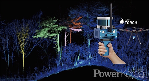
Map Torch is a GPS-free SLAM mobile mapping device
A.M.AUTONOMY Co.,Ltd. (CEO Yongdeuk Shin) is a startup specializing in three-dimensional mapping, which uses lidar sensors and SLAM technology to visualize space in three dimensions.
The company has been working at Robot Group, a government-funded think tank, focusing on SLAM. SLAM is a technology that allows machines equipped with lidar sensors, such as robots, to locate, orient, map, and navigate themselves to get to their destination, so they don’t need GPS to know where they are. The company has a proprietary SLAM technology, which it has leveraged to become a recognized leader in indoor space measurement.
MAP-TORCH, a handheld mobile mapping system (MMS), was developed utilizing this technology. The existing mobile mapping devices were dependent on GPS and were highly affected by the characteristics of the location. However, MAP-TORCH, which applies SLAM technology, does not rely on GPS and is not limited by the location.
It is equipped with a lidar sensor that can measure 300,000 distances in a second, and uses it to scan the space as it moves to map it. “MAP-TORCH is a device that moves through space and acquires three-dimensional spatial information,” says CEO Shin. All you have to do is turn it on, pick it up, and move it around to get three-dimensional spatial information,” said Shin. The indoor local error is 0.023 meters, and the outdoor cumulative error is only 0.182%. This is one of the best in the world and has been certified by the Korea Testing Laboratory.
 |
Robots and drones can map where we cannot reach
Turning any space into 3D
MAP-TORCH is light enough to be carried in the hand and easy enough to install on a robot or drone. Typical handheld mapping devices can be carried by humans, but are often not suitable for installation on robots or drones. However, this one can be mounted on a robot or drone, so it can be used to map narrow spaces, high places, or dangerous sites that humans cannot reach.
MAP-TORCH can be used in various fields such as construction, forest resource survey, mineral resource survey, cargo volume survey, offshore plant, real estate, cultural property, safety, and environmental projects, as well as robots and drones for autonomous driving. This is expected to be well received in the future carbon neutral era as it can measure and analyze forest assets such as tree assets and carbon uptake by digitizing forests that are difficult to find in three dimensions. The mapping results can be applied to drones and robots to help them avoid obstacles and find their way around, to analyze changes in construction processes in three dimensions, and to predict smart cities, metaverses, and crop growth and yield.
 |
We are preparing Magoworks, which can acquire and analyze environmental figures and 3D maps remotely using LTE, an autonomous driving system that uses SLAM technology to plan routes and avoid collisions and draw maps by itself. “Our goal is to digitize all of the real world we live in in three dimensions,” says Shin. “Currently, we are developing 3D spatial information and equipment to digitize spaces that are accessible to humans, but in the future, we plan to develop robots and drones to digitize spaces that are inaccessible to humans.”
신태섭 기자 tss79@naver.com